
Travel Impacts
Find out about road closures, detours and disruptions from infrastructure works across Canberra.
Plan your journey
Check other road closures information and scheduled maintenance at the City Services website.
Visit the National Capital Authority website for information about the Commonwealth Avenue Bridge Renewal Project.
Cyclist wayfinding map
Plan your cycling through the city and the Commonwealth Avenue corridor using the Cyclist Wayfinding Map.
The map shows alternative and recommended routes during temporary closures linked to construction works in the area.
Travel by regions
City
Projects impacting this area:
- Light Rail Stage 2A
- New lyric theatre
- Commonwealth Avenue Bridge renewal project (National Capital Authority)
Commonwealth Avenue
- Intermittent road impacts and full lane closures are planned over the months of July and August, including:
- Median lanes are closed. Reduced speed limit signage will be in place. Access to Acton Waterfront via Albert Street.
- Northbound (Acton Waterfront) bus stop is closed until further notice.
- Bus services to and from the city may be delayed due to lane closures and light rail works.
Edinburgh Avenue
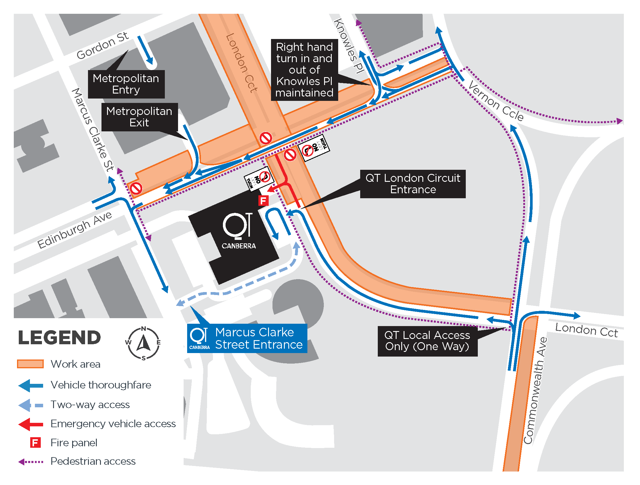
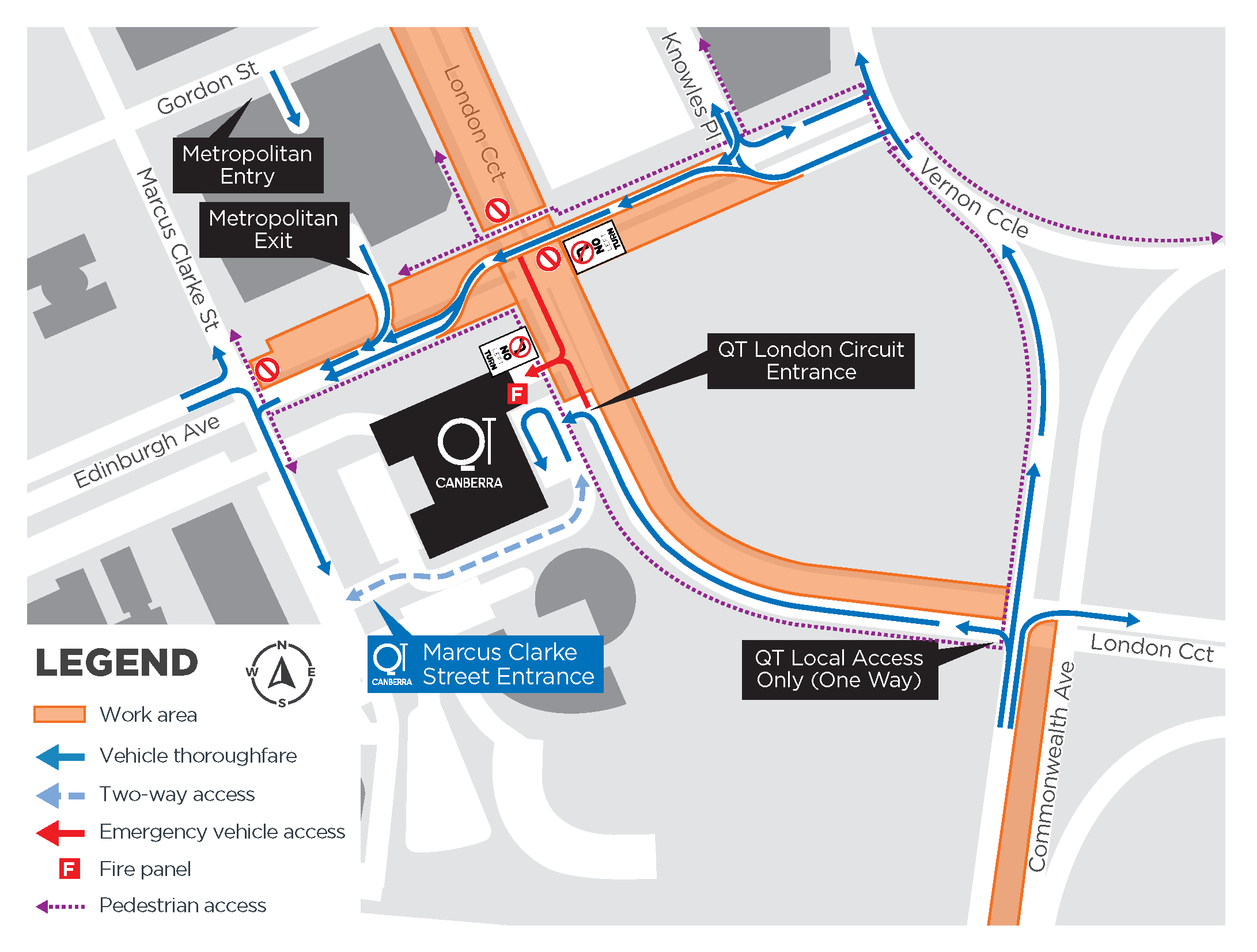
- From 5am Monday 13 July to 8pm Sunday 26 July, traffic on Edinburgh Ave will be reduced to one lane between Knowles Place and The Mews, travelling westbound only. View map.
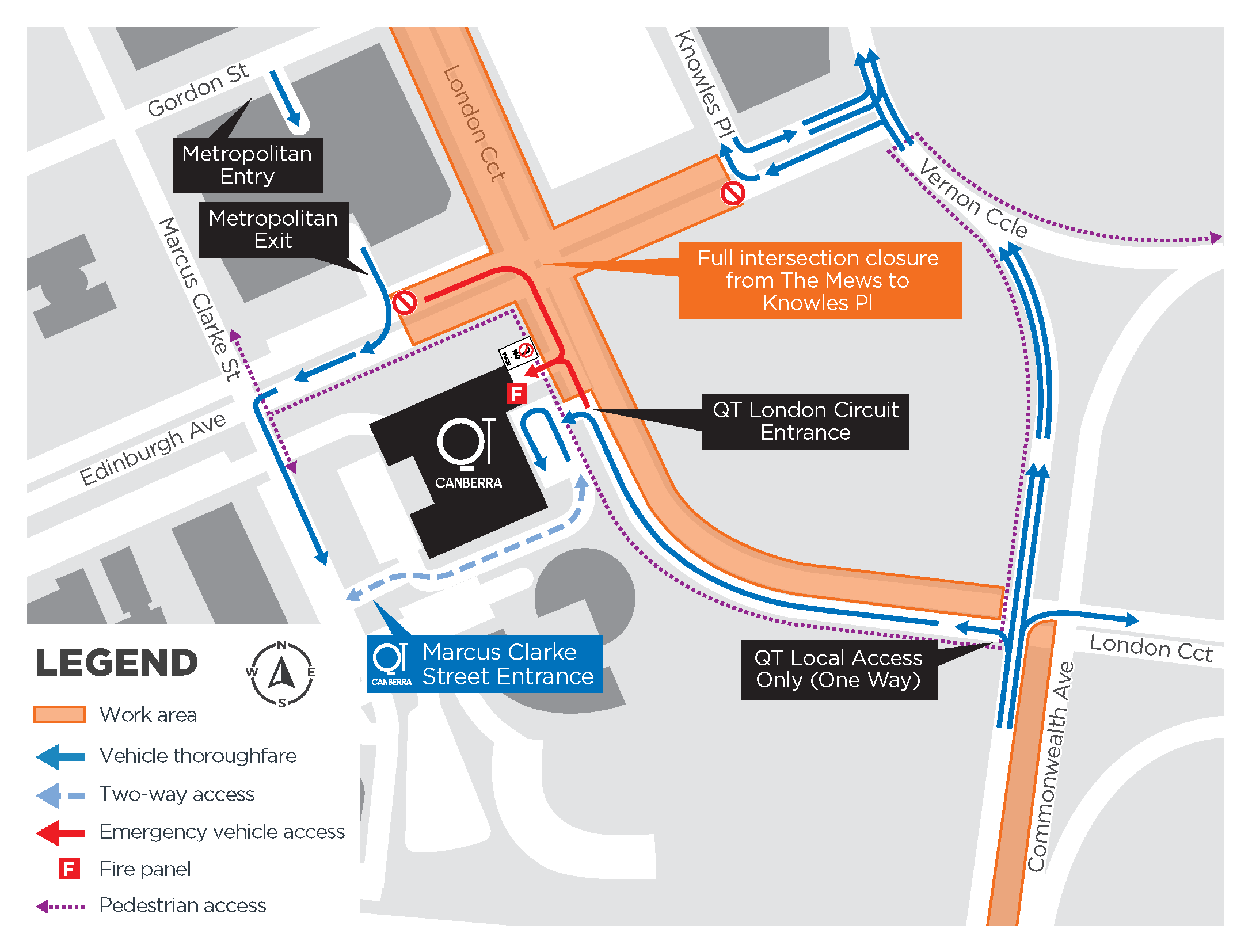
- From 8pm Sunday 26 July to 5am Monday 27 July, Edinburgh Avenue between The Mews and Knowles Place will be closed. Vehicle entry in and exit out of Knowles Place will be maintained. View map.
- From 5am Monday 27 July to 8pm Sunday 9 August, traffic on Edinburgh Avenue will be reduced to one lane between Knowles Place and The Mews travelling westbound only. View Map.
- From 8pm Sunday 9 August to 5am Monday 10 August, Edinburgh Avenue between The Mews and Knowles Place will be closed. Vehicle entry in and exit out of Knowles Place will be maintained. View map.
London Circuit
- Western side closed between Northbourne Avenue and Commonwealth Avenue.
- East side sections closed between Northbourne Avenue and Theatre Lane.
- Pedestrian and wheelchair access maintained around London Circuit.
- Shared paths remain open but reduce speed near works.
- From 28 May: the London Circuit pedestrian crossing at the southern end of Knowles Place will be closed. Pedestrians will be directed to use the London Circuit pedestrian crossings at the northern end of Knowles Place (in front of the Reserve Bank of Australia building) or at Edinburgh Ave. View map.
- From 13 July: temporary lane closures will be in place on London Circuit between Baileys Arcade and Ainslie Place for up to three months.
- Theatre Lane: (behind Canberra Theatre Centre) access restricted and closed to public access during lyric theatre works.
Northbourne Avenue/Alinga Street
- Turning right from Northbourne Avenue to Alinga Street is not permitted.
- Local vehicles (e.g. delivery vehicles, taxis) travelling on Alinga Street east must turn left onto Northbourne Avenue.
- Vehicles are not permitted to travel through the Alinga Street/Northbourne Avenue intersection to Alinga Street west.
- Northbourne Avenue permanent southbound single lane reduction between Alinga Street and London Circuit from Wednesday 3 June. Detours will be in place.
Maps
- Light Rail Stage 2A interactive construction impacts map
- City car parking map
- Traffic Map – Northbourne Avenue/Alinga Street
Inner South
Projects impacting this area:
Commonwealth Park and Acton Waterfront
- Some pedestrian paths have been changed or redirected. Signage is in place.
Belconnen
Projects impacting this area:
- From Monday 29 June, no pedestrian access at the William Hovell Drive, Drake-Brockman Drive and Kingsford Smith Drive roundabout.
- Pedestrian detours in place to Belconnen Way, Kingsford Smith Drive, Murranji Street and Florina Place.
Maps
Tuggeranong
Projects impacting this area:
Monaro Highway
- Pavement construction continues across the work area.
- Temporary traffic lights are in place for northbound traffic at the Monaro Highway and Lanyon Drive intersection.
- During weekday off-peak hours, traffic on the Monaro Highway may reduce to one lane in each direction.
Woden, Weston Creek and Molonglo
Projects impacting this area:
Callam Street
- Reopened to private vehicles between Launceston Street and Matilda Street and between Neptune Street and Bradley Street.
- Callam Street between Matilda Street and Bradley Street access is restricted to bus access only.
Bowes-Bradley connection
- The local access shared zone between Bowes Street and Bradley Street remains closed to cars until end July 2026.
Bowes Street
- The stretch of Bowes Street outside Grand Central Towers is reverting to one-way local access traffic.
Parking
Theatre Lane car park
- Parking area opposite Sydney building is closed.
- Accessible parking, share car spaces, and designated Legislative Assembly, medical, and government vehicles have been relocated to City Hill and Hobart Place car parks.
- Find more about available parking at City Services website.
City parking
There are more than 10,000 car parks in the Canberra’s city centre. This includes covered and uncovered parking, in addition to accessible parking spaces. If you decide to travel to the city by car, a map of available car parks is below.
A number of private sector projects are also currently underway in the city. Please follow signage in place, allow for additional travel time and plan ahead.
You can also:
- view our Our Canberra article that lists more than 10 car parks options available for public use.
- Use applications including Parkopedia and EasyPark which provide practical information on parking options.
Remember to read the signs displayed for days and times and when pay parking applies.
Subscribe
To find out more about infrastructure updates, you can subscribe to project newsletters.